ArcGIS GeoPlanner allows you to import existing features into a scenario so you can begin a plan or design from a known baseline. Starting a design or plan from existing conditions provides an easy method to compare before and after scenarios. Using a dashboard in GeoPlanner's Evaluate segment, you can quickly see the impacts of your proposed design and how it differs from current conditions.
GeoPlanner can import points, lines, and polygons from feature layers shared on ArcGIS Online or your portal. The importer allows you to map source feature types to target feature types. For example, you want to import agricultural data into a GeoPlanner scenario in a project based on the GeoPlanner template for land use planning. The Import Scenario tool allows you to map source features that represent fruit to target features of type Agricultural Orchard and source features of type grain to target features of type Agricultural Crop. The importer can also import attribute values associated with geometries into a target scenario. If your project feature service has default values configured for one or more attributes, the scenario importer initializes those default values in the target scenario.
Once you have imported features into a scenario, use that scenario the same way as any other scenario in GeoPlanner. This includes the following functionality:
- Create new, edit, or delete existing features.
- Visualize feature summaries in dashboard charts and key performance indicators in dashboard gauges.
- Execute analysis tools on the Explore segment's Analyze tool menu to understand your design's impact.
- Save the scenario that contains the imported features to a new scenario using the Save button's Save Scenario As utility.
Note:
Currently, you can import a maximum of 10000 polygons, 15000 lines, and 25000 points into a scenario during a single import operation. If you need to import more features, create separate layers using Map Viewer available in your portal or ArcGIS Online. You can also use the Add to Design Layers tool from a feature layer's context menu in the Contents pane.
The following steps help you understand how to use the GeoPlanner Import Features to Scenario tool.
Import features to scenario
To import existing features into a scenario, add a feature layer to a GeoPlanner project and specify which scenario you will import into.
- In GeoPlanner, use the Add Data tool to add one or more feature layers to a project. If you want to import file-based datasets like geodatabase feature classes or shapefiles for use in GeoPlanner, see Publish features and Add files from your computer.
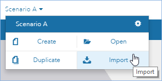
- In the upper-left corner of the application, click the scenario dropdown and choose Import.
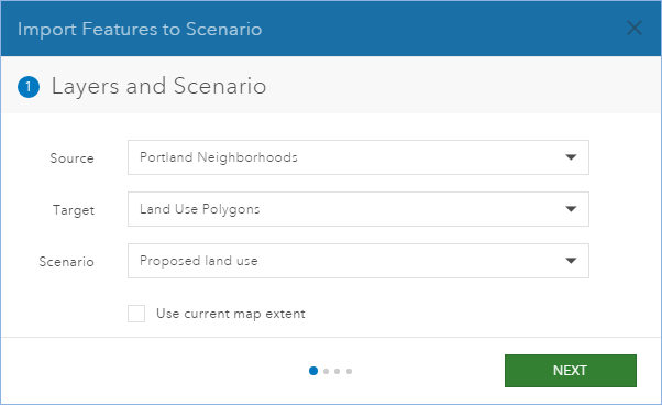
- In the Import Features to Scenario dialog box, click the Source dropdown and choose the layer you added in step 1. Set Target to your scenario layer. Click Next.
- Click the Scenario drop-down list and choose a scenario.
Note:
You can optionally check Use current map extent to import only source features visible in the current map extent. This allows you to import a subset (the visible features) into your target scenario.
- Click Next to advance the import tool to the Feature Type Mapping pane.
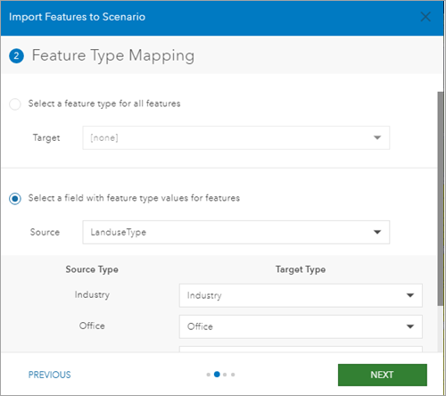
- Indicate how you want to map source feature types to target feature types by choosing one of the following options:
- To import all source features into a single target feature type, click Select a feature type for all features. Choose a target feature type from the drop-down list.
- To map source features to specific target features, click Select a field with feature type values for features and choose a source field from the drop-down list. Source types display at the bottom of the dialog box with the target type drop-downs. For each source type, choose a target type.
- Click Next to advance the import tool to the Field Mapping pane.
- Optionally, for each source field, choose a target field from the drop-down list.
Note:
You can only map the source to target fields that will not result in data loss or truncation. For example, you can only map source double fields to target double fields. The following combinations are allowed:
Source field type Target field types Date
Date
Double
Double
Float
Double, Float
GlobalID
GlobalID
GUID
GUID
Long
Double, Float, Long
ObjectID
Long
Short
Double, Float, Long, Short
Text
Text
- Click Next to advance the import tool to the Execution Status pane.
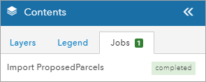
- Click Import. The Import Features to Scenario dialog box closes. A spinning animation displays on the Jobs tab of the Contents window. Once this animation stops, your feature import has completed.
- Turn on the appropriate Active Scenario layer to display your imported features.
Note:
You can import any feature layer with a geometryType property of esriGeometryPolygon, esriGeometryPolyline, or esriGeometryPoint. Feature layers of type esriGeometryMultipoint cannot be imported.
Import a single feature into a scenario layer or a study area
GeoPlanner enables you to import a single feature by clicking on it to display a pop—up dialog. The pop—up dialog in GeoPlanner includes an Import option for feature layers. Use this tool to quickly and easily import a single feature into a scenario layer or study area. Follow these steps to use this utility:
- In the Explore or Evaluate segments, click on a feature that you want to import into a scenario or study area.
- Scroll to the bottom of the pop—up window and click Import.
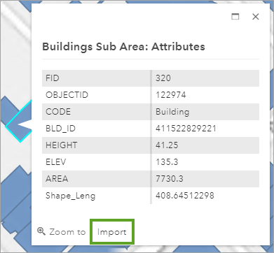
- In the Import dialog, click the Layer drop down and select StudyArea to import the feature as a study area in the current project. To import the feature into a scenario design layer, click the name of the scenario.
- If you chose StudyArea in step 3, type in a name.
- Click Import.